Short Courses
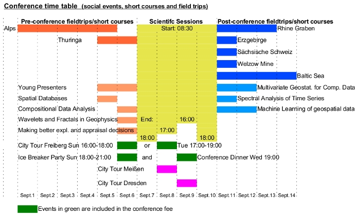
- Young presenters' Programme (September 5-6, 2015)
- Introduction to spatial databases (September 5, 2015)
- Introduction to Compositional Data Analysis (September 6, 2015)
- Wavelets and Fractals in Geophysics: an overview (September 6, 2015)
- Making Better Exploration and Appraisal Decisions Using Modern Asset Valuation Methods (September 6, 2015)
- Multivariate Geostatistics for compositional data (September 11-12, 2015)
- Spectral analysis of time series (September 11, 2015) (Cancelled)
- Machine Learning of geospatial data: achievements and new trends (September 11-12, 2015)

Young presenters Programme↑
A special course is offered for young presenters. See Young presenters program for details.This short course is included in the student conference fee, though a separate registration will be required.
Introduction to spatial databases↑
- organized by: MSc Geoinf. P. Gabriel, MSc Geoinf. J. Gietzel, Institut für Geophysik und Geoinformatik, TU Bergakademie Freiberg, Freiberg, Germany
- Venue: TU Bergakademie Freiberg, PC pool
- Date: September 5, 2015
- Time: 9am-12am, 2pm-5pm
- Min. number of participants: 10
- Max. number of participants: 20
- costs per participant: preliminary price $140 (students/retired: $70)
The workshop will address common spatial databases like Oracle Spatial and PostGIS but also less common databases like MongoDB or CouchDB. Different contents and meanings of the term topology for 2D and 3D applications as well as the use of spatial indexes as R-Trees, Quadtrees, GiST, Geohashes, and Hilbert Curves will be discussed. Then steps required for the integration of data sets in such databases will be analyzed. Eventually the workshop will cover how the data will be made available to other users, e.g. via web applications and web mapping toolkits. Hands-on exercises with computers will be part of the workshop, providing some first experience of practical 3d geodata management for the participants.
Introduction to Compositional Data Analysis↑
- organized by: V. Pawlowsky-Glahn (Universitat de Girona), and J.J. Egozcue (Universitat Politecnica de Catalunya)
- Venue: TU Bergakademie Freiberg, PC pool
- Date: September 6, 2015
- Time: 9am-12am, 2pm-5pm
- Min. number of participants: will be completed soon
- Max. number of participants: 20
- costs per participant: preliminary price $120 (students/retired: $60)
Compositional data are omnipresent in the geosciences, from the classical geochemical compositions of soil, water, air, vegetal tissue, sediment or rock samples to (modern and palaeo-)ecological population structures, passing through particle size fraction compositions. The workshop will present several tools of descriptive analysis of compositional data, as well as the fundamental concepts of the algebraic-geometric structure of the simplex, the sample space of this kind of data, necessary to build more advanced models. The open source, cross-plattform software CoDaPack will be introduced and used for all purposes.
Wavelets and Fractals in Geophysics: An Overview↑
- organized by: Prof. E. Chandrasekhar (Department of Earth Sciences, Indian Institute of Technology, Bombay, India)
- Venue: TU Bergakademie Freiberg, to determine
- Date: September 6, 2015
- Time: 9:00am-12:15am, 2:00pm-5:15pm
- Min. number of participants: 10
- Max. number of participants: 20
- costs per participant: preliminary price $150 (students/retired: $75)
The subject of wavelet and fractal analyses is fast developing and has drawn a great deal of attention of scientists in varied disciplines of science and engineering. The wavelet transformation is a localized transformation of signals in space-time and time-frequency domains. This property can be effectively utilized to extract information from signals that is not possible with the conventional signal processing techniques. Over the past decade, wavelets, multiresolution and multifractal analyses have been formalized into a thorough mathematical framework and have found a variety of applications with significant impact in the analyses of several geophysical processes such as geomagnetism, atmospheric turbulence, space-time rainfall, ocean wind waves, fluid dynamics, seafloor bathymetry, geophysical well-logging and climate change studies among others.
This course is mainly designed for scientists and researchers to help view their research problems in a new angle with these novel signal analysis tools. The course will cover basic principles and a thorough introduction of wavelets and fractals, with a special reference to their applications in geophysical well-log data analysis and geomagnetism. Special emphasis is given to interpretation of the analyses results. The short course will have the following structure
- Lecture 1 (9:00-10:30): Introduction to wavelets: Principles, Mathematical Concepts and Properties; Continuous and Discrete Wavelet Transformations (CWT and DWT)
- Lecture 2 (10:45-12:15): Application of CWT to geophysical well-log data and interpretation; CWT with complex wavelets and their application in geomagnetism
- Lecture 3 (14:00-15:30): Introduction to fractals and multifractals: Various methods of analysis; Mathematical concepts of Detrended Fluctuation Analysis (DFA) and Multifractal DFA algorithms
- Lecture 4 (15:45-17:15): Fractal Analyses of: Geophysical well-log data and interpretation, and Geomagnetic data and interpretation.
Making Better Exploration and Appraisal Decisions Using Modern Asset Valuation Methods↑
-
David Laughton, Professor. School of Business University of Alberta and David Laughton Consulting Ltd.
Gordon Kaufman, Professor Emeritus, Sloan School of Management, MIT - Venue: TU Bergakademie Freiberg
- Date: September 06, 2015
- Time: 9:00am-12:00am, and 2:00pm-5:00pm
- Min. number of participants: 4
- Max. number of participants: 12
- costs per participant: preliminary price $120 (students/retired: $60)
In the morning we overview asset valuation techniques developed over the last 40 years. Modern asset valuation techniques allow firms in extractive industries to make better assessments of exploration and appraisal alternatives than are afforded by methods currently employed by most exploration and development firms. New developments include:
- Detailed models of the joint dynamics of uncertainty resolution in geological and commercial variables that underpin uncertainties in mineral asset values.
- Optimization techniques that allow firms to consider complex decision tree models of exploration and appraisal decision alternatives.
- An approach to valuation that allows a refined determination of how financial markets value risk. This approach overcomes several biases present in current decision-making processes deployed by many firms—biases against activities such as exploration that have long-term payoffs in particular. To bootstrap understanding participants will work through a short series of examples.
Multivariate Geostatistics for compositional data↑
- organized by: U. Mueller (Edith Cowan University, Perth, Western Australia) and R. Tolosana-Delgado (Helmholtz Institut Freiberg for Resource Technology, Freiberg, Germany)
- Venue: TU Bergakademie Freiberg, PC pool
- Date: September 11-12, 2015
- Time: 9:00am-12:30am, and 2:00pm-5:30pm, both days, with 30' breaks
- Min. number of participants: 5
- Max. number of participants: 20
- costs per participant: preliminary price $160 (students/retired: $80)
Geostatistics has become the standard tool of interpolation of data sets in the mathematical geosciences, with applications in several fields: oil or water well production forecasting, evaluation of mineral resources, delineation of polluted soils, etc. In all these cases, Geostatistics has been massively applied for univariate problems. Though multivariate case studies do also exist (e.g., in polymetallic deposits or polyelemental pollution), they are by no means so popular or understood. An additional difficulty most often not considered in these cases is the compositional nature of the data sets, i.e. that the variables sum up to 100%: from sand-silt-clay compositional-textural information of soils, to shale-Fe-chert-P-Mn compositions of Banded Iron Formation ores, the spurious correlation induced by the sum to a constant value has been most commonly ignored. This course targets those people who have some experience with both univariate geostatistics and the logratio approach to compositional data analysis (the pre-conference course is enough for the latter), and who want to learn how to apply the logratio methods in the particular case of spatially-dependent compositional data. The course will cover the theoretical and practical aspects of: cross-variogram estimation, with and without anisotropy; joint modelling of variogram systems; logratio cokriging and its properties; basics of simulation of compositional random fields; and upscaling/block cokriging ideas. The practical part will be dealt with in R using scripts taylored for each task, hence a bit of experience with R (or any analogous interpreted language, e.g. Matlab) is recommended but not required.
A practical course on the spectral analysis of time series in Geology, Climatology, Environmental Sciences and Engineering↑
- organized by: Dr. Eulogio Pardo-Igúzquiza (Geological Survey of Spain)
- Venue: TU Bergakademie Freiberg, will be announced later
- Date: September 11, 2015
- Time: 9am-12am, 2pm-5pm
- Min. number of participants: 10
- Max. number of participants: 30
- costs per participant: preliminary price $120 (students/retired: $60)
The spectral analysis of time series is of paramount importance in many scientific disciplines: geosciences, physics, medicine, astronomy, meteorology, economics, ... to name just a few. The first methods were based on Fourier series but were extended later to parametric approaches like maximum entropy. More recently, soft computing techniques, like neural networks computing, have allowed to relax the assumptions required by many standard methods.
This course covers the theory and practical applications of the spectral analysis of time series. Classical methods like Fourier methods, Blackman-Tuckey, maximum entropy, multi-taper methods and soft-computing methodologies are considered. Problems of special interest are the spectral analysis of: time series with uneven sampling, time series of compositional data, time series of averaged or integrated values, time series of several variables (multivariate data), non-Gaussian and non-stationary time series, simulation of time series with different models of signal and noise, software for spectral analysis, applications in any area of Earth and Physical Sciences.
Basic knowledge in statistics and calculus (first year university level). It is necessary to bring a laptop in order to perform the practical exercises.
Machine Learning of geospatial data: achievements and new trends↑
- organized by: Prof. M. Kanevski (IDYST Institute, University of Lausanne, Switzerland)
- Venue: TU Bergakademie Freiberg, will be announced later
- Date: September 11-12, 2015
- Time: 2015/09/11: 9am-12am, 2pm-5pm (lectures and seminars); 2015/09/12: 9am-12am (practices)
- Min. number of participants: 5
- Max. number of participants: 20
- costs per participant: preliminary price $130 (student/retired: $65)
Machine learning (ML) is a rapidly developing interdisciplinary approach to complex data analysis, modelling and visualization. It plays an extremely important role in data mining in different scientific fields and in many practical applications. At present ML is widely used as an efficient tool in GI Sciences, remote sensing images processing, environmental monitoring and space-time forecasting. The short course presents an introduction to advanced ML algorithms, important contemporary achievements and new trends in ML applications in analysis, modelling and prediction of high dimensional and multivariate environmental data. The main topics, presented within the framework of a generic methodology, include, between others: detection of patterns and predictability, features selection, supervised and unsupervised learning from data using neural networks and kernel-based methods, visualization of data and the results. Real case studies consider environment pollution, natural hazards, renewable resources, topo-climatic modelling, etc. The course is accompanied by the demonstrations and practices following the principle "from how-to-do-it to do-it-yourself" using user friendly software.

